After waking up in Marvao and spending our morning exploring, we set off to Evora. Of course, Tyler rolled his ankle on those beautiful cobblestone streets the night before, and I woke up feeling the beginning of a fever. Still, we had 2 more stops on our road trip, beginning with the city of Evora, followed by the nearby Monsaraz, then the city of Beja. By the time we had lunch, Kevin realized his couple of Pages were too ill, and he promptly drove us the last 3 hours home to the Algarve.
Before our trip was cut short, we did get to explore Evora. We also had an incredible lunch at a restaurant that only serves 9 people at a time. “Botequim da Mouraria” is run by a welcoming Portuguese couple. In their small restaurant, there’s bar seating only, which means that we were incredibly lucky to arrive in time for lunch and find 3 empty chairs waiting for us. The service and the food were excellent. This was one of those places Kevin had found in the course of his detailed research, and it was very much worth the hype.
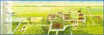
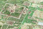
After lunch, we explored Evora and its incredible history. A very old city, Evora still has Roman ruins and an incredible variety of historic architecture. On all our other stops, I read aloud to the guys various historical fun facts. Being sick in Evora meant that I didn’t really do this, and so we learned a bit less there than everywhere else. The city is more than 2000 years old, and was occupied by the Celts and the Moors before becoming the #2 city in Portugal for a time, becoming the site of much lavish spending on the behalf of Portuguese rulers.
Here are a couple of other fun facts about Evora:
Évora has a history dating back more than two millennia.
It was known as Ebora by the Celts, a tribal confederacy, south of the Lusitanians (and of Tagus river), who made the town their regional capital.
The etymological origin of the name Ebora is from the ancient Celtic word ebora/ebura, plural genitive of the word eburos (yew), name of a species of tree, so its name means “of yew tree.” The city of York, in northern England, at the time of the Roman Empire, was called Eboracum/Eburacum, named after the ancient Celtic place name Ebora Kon (Place of Yew Trees), so the old name of York is etymologically related to the city of Évora.[6]
Évora is also remarkable for reasons other than its monumental heritage related to significant historic events. The 16th century was a time of major urban planning and great intellectual and religious influence. While Évora also has many noteworthy 16th-century patrician houses (Cordovil house, the house of Garcia de Resende), the unique quality of the city arises from the coherence of the minor architecture of the 16th, 17th and 18th centuries. This unity finds its overall expression in the form of numerous low whitewashed houses, decorated with Dutch tiles and wrought-iron balconies and covered with tile roofs or terraces which line narrow streets of medieval configuration and which in other areas bears witness to the concentric growth of the town until the 17th century. It also served to strengthen the fundamental unity of a type of architecture that is perfectly adapted to the climate and the location.
Évora remained mainly undamaged by the great earthquake of 1755 that destroyed many towns in Portugal, including Lisbon. The monuments of the Historic Centre of Évora bear witness to their profound influence on Portuguese architecture in Brazil.
In retrospect, while we recognized how beautiful Evora was, I was a bit too sick to recognize and appreciate the signs of its long storied history. It was also clearly packed with tourists from all of the world, which became a bit of a distraction itself. All the same, we managed to take a few photos. Enjoy!
our amazing lunch!
tourists taking photos of local students on a field trip
being holy
standing near some incredibly Manueline architecture
As Kristopher pointed out, the Angkor temples that we saw were actually amazing. That is, while the word ‘amazing’ is frequently used, it rarely describes things that amaze people, but when you talk about Angkor Watt and surrounding temples, you’re really describing history and buildings and architecture as “amazing” because you really are amazed.
We had a long journey that day, in the hot, hot, heat of Cambodia. Have you ever sweat so much that you didn’t have to pee, despite drinking several bottles of water? Because that’s how much we sweat. It was gross, and it was worth every bit of it.
Before I go on and on about what we saw and how incredible the Angkorian temples were (plus maps!), here’s a brief backgrounder from UNESCO:
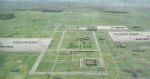
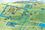
Angkor, in Cambodia’s northern province of Siem Reap, is one of the most important archaeological sites of Southeast Asia. It extends over approximately 400 square kilometres and consists of scores of temples, hydraulic structures (basins, dykes, reservoirs, canals) as well as communication routes. For several centuries Angkor, was the centre of the Khmer Kingdom. With impressive monuments, several different ancient urban plans and large water reservoirs, the site is a unique concentration of features testifying to an exceptional civilization. Temples such as Angkor Wat, the Bayon, Preah Khan and Ta Prohm, exemplars of Khmer architecture, are closely linked to their geographical context as well as being imbued with symbolic significance. The architecture and layout of the successive capitals bear witness to a high level of social order and ranking within the Khmer Empire. Angkor is therefore a major site exemplifying cultural, religious and symbolic values, as well as containing high architectural, archaeological and artistic significance. (UNESCO)
To learn more, I highly recommend that you check out the article yourself to read the Long Description and learn a bit more about Khmer (Cambodian) history.
Below are some maps to give a sense of how things are laid out. The East and West Barays are sometimes presented as bodies of water (especially on Google Maps), but they’re really wetlands that now exist where the Angkorian Empire had created man-made lakes. If this mixed presentation of maps sounds confusing, that’s because it is. Google Maps accuracy was not great during this trip.
Here’s a map of the adventure we took, to be followed by stories.
Around 10am on Saturday morning, after eating breakfast at our hotel, we loaded ourselves up on our motorcycles and headed off. Not so fast though – the Page kids had some difficulty getting started.
Problem 1: the motorcycles were too tall for me! It probably took me 5 minutes to figure how to actually get on the back of Kevin’s motorcycle. It involved much hysteria (on my part), and much encouragement, then frustration, then encouragement (on Kevin’s part). These motorcycles have quite a bit of suspension, to make for better riding on bumpy roads, but the suspension also makes the bikes quite a bit taller than your average motorcycle.
Problem 2: Tyler’s motorcycle wouldn’t start. Kevin and I had already gone half a block, but it was clear Tyler’s bike wasn’t starting. We circled the block, got off of Kevin’s motorcycle (also difficult), and Kevin started Tyler’s motorcycle with his magical skills. Then it was back on the motorcycle (only slightly less difficult the second time around), and set off on our day’s adventure.
From the middle of Siem Reap, we rode about 15 minutes to the ticket booth for Angkor Archaeological Park, bought our tickets, and rode another 15 minutes to Angkor Watt. This distance was the reason we opted to explore Angkor via motorcycle and not actual bicycles.
We then arrived at our first stop, Angkor Watt, where I was promptly convinced to buy a $10 scarf from a local. She assured me that it was 100% necessary to wear one in the temples. So, I bought this overpriced scarf (despite having 3 scarves in my suitcase at the hotel! I am a fool.) to wrap around my bare legs, and then spent the next hour carrying it around. I felt a bit better when I was asked to put it on to get into the main temple eventually, though I didn’t feel better when I saw a different lady selling the same scarf for $3.
Angkor Watt was incredibly large and impressive and beautiful and detailed. And then, when we looked up, we saw a ring rainbow around the sun!! We took an outrageous number of pictures, and Kevin also captured a video of us attempting to take a “jump” photo:
After spending more than an hour exploring the beauty of Angkor Watt, we made our way back to our motorcycles and headed north of Angkor Thom. We stopped at the Bayon Temple, which had been the focal point of Angkor Thom, and spent quite a bit of time walking around feeling like we were in the 90s video game, PitFall. The Bayon sits in the middle of a ring road, so we were able to film the temple as we drove around the full circle:
After Angkor Thom, we decided to take a bit of an adventure detour and head over to West Mebon, a temple in the middle of a lake. It seemed to be just a quick side-road jaunt away. We headed west out of the Angkor Thom complex, then a bit north. As the navigator, I was in charge of getting us there, and I had a pretty good handle on things. That is, until we came to a fork in the road and I chose the road that looked more serious (that is, the road that wasn’t just a thin road through a village). Once I realized I’d chosen wrong, I figured “hey, no big deal, we can take one of the many side roads that connect back to that village road!”. The first few “side roads” looked more like “side walkways” so we passed them. Finally we found a road that looked not too bad. It was so not-too-bad that it actually took us to someone’s house. And then we had to drive over their concrete side-yard to reach a path behind their house. That should’ve been a sign of things to come.
We waved to the children, and ignored the concerned look on the face of the old man waving at us. Also a sign.
The path started out okay. We passed a 5 foot ditch, we passed through a portion of path with barbed wire on both sides, but we were surviving. Then, we started to go uphill. Just as I was realizing “shit, this road is totally not a road and all I see ahead is jungle”, I realized that our bike was falling to the side and Kevin was yelling. We were now both standing on one leg, in a bush, straddling this too-tall bike. Somehow I managed not to get burned, and once I heard Kevin yelling “get off the bike, I think my leg might break soon”, I pulled my left leg into the bush, tried to hold up the bike so all the pressure wouldn’t be on Kevin and his right leg, and yelled for Kristopher to come help us (He and Tyler were stopped, safely, 10 feet behind us). Kristopher lifted the bike, and Kevin swung his left leg back off the bike to stand in the bush as well, leg intact. Our adventure on this non-road was over.
KP and I walked back, as Tyler and Kevin manoeuvred and their bikes back to the house, and back to the comparatively very real part of the side-road-path. We didn’t see that old man who’d likely warned us, but I’m sure he’s seen others make the same mistake, and it’s likely he’ll see more in the future.
Not content to quit just yet, we made it back to the main road, and tried another side road. About ten seconds into that, we realized it was too sandy for safe riding, and promptly turned around. “We’ll just google this one to see if it’s worth it”, was our resolution. Here’s the result, btw. It seems pretty awesome, but we didn’t have time to return the next day.
So, fully humbled, we rode the motorcyles back through Angkor Thom, and headed north, then east, then south, to see a variety of interesting temples. The last one was probably our favourite of the day – Banteay Kdei. It was a lot more ruin-y than the others, and it was punctuated by enormous, incredible trees growing out of everything.
Check out our many, many photos from the day. Then, book your ticket to Cambodia so that you can see these for yourselves. SO worth it. (PS: I’ll have more photos coming in the next few days from this particular adventure, as Kevin’s phone died in the afternoon, and only Tyler and Kristopher have photos from certain temples.)
the Page kids at Angkor Watt
rainbow sun circle!
our first series of band photos
temple carvings
more band photos
Climbing up to the main temple of Angkor Watt
Tyler making good use of my new scarf
Feet in the middle at the Bayon Temple at Angkor Thom